Africa Political Wall Map In Tube - Laminated.


Africa Political Wall Map In Tube - Laminated.
Africa Political Wall Map.This detailed map of Africa at a 1:9 000 000 scale shows colour coded countries with international,
disputed and undefined country boundries. The map indicates capital cities, major cities,
towns, major roads, minor roads, seasonal roads, international and national airports,
rivers and lakes with names, latitude, longitude, tropic and equator lines,
the hi... more details

price history Price history

BP = Best Price   HP = Highest Price

Current Price: R395.00

loading...
Description
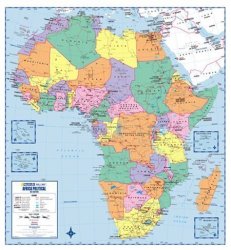
Africa Political Wall Map.This detailed map of Africa at a 1:9 000 000 scale shows colour coded countries with international,
disputed and undefined country boundries. The map indicates capital cities, major cities,
towns, major roads, minor roads, seasonal roads, international and national airports,
rivers and lakes with names, latitude, longitude, tropic and equator lines,
the highest peak in each country.
Coverage also includes Seychelles, Mauritius and Madagascar.Scale:  1:9 000 000.Laminated.
Edition: 1st Edition @ 2009.
Size: 0.87m Wide x 0.98m High.
Condition: New.
Price: R 395.00 Inc Vat.
 
There are no offers currently available for this product. The last offer was seen on 04/07/2017 from BidorBuy for R395.00
This site is protected by reCAPTCHA and the Google Privacy Policy and Terms of Service apply.