Description
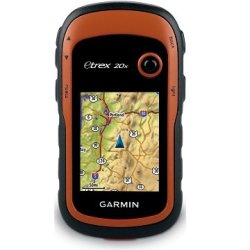
GarminOutdoor GPS- eTrex 20X - OSM
The GarminOutdoor GPS- eTrex 20X - OSM has preloaded OSM Recreational Map of Africa that supports and enhances a range of outdoor activities, such as hiking, geocaching, mountaineering and fishing.
Information
TheGarminOutdoor GPS- eTrex 20X - OSMis our upgraded version of the popular eTrex 20, with enhanced screen resolution and extended internal memory to hold more maps. The preloaded OSM Recreational Map of Africa supports and enhances a range of outdoor activities, such as hiking, geocaching, mountaineering and fishing. eTrex 20x has enhanced features compared to eTrex 20, while maintaining its ease-of-use, affordability and legendary durability.
In the Box
USB cable
Documentation
eTrex 20x
Features
See the Way
eTrex 20x has an enhanced 2.2 inch, 65K colour, sunlight-readable display. Durable and water-resistant, eTrex 20x is built to withstand the elements. It has an upgraded interface yet retains its toughness to withstand dust, dirt, humidity or water.
Go Anywhere
Fit your eTrex 20x just about anywhere, using an array of compatible mounts. Use the auto mount capability and City Navigator NT maps for turn-by-turn driving directions, or the rugged mount for your bike or quad. You can even mount to a boat for fishing or sailing trips.
Go Global
The eTrex series can track both GPS and GLONASS satellites simultaneously - it has the ability to lock on to 24 more satellites than using just GPS. What's more, the time it takes to "lock on" to a position is (on average) 20% faster than using GPS alone. With its high-sensitivity EGNOS-enabled GPS receiver and HotFix satellite prediction, eTrex locates your position quickly and precisely and maintains its GPS location even in heavy cover and deep valleys.
Preloaded Recreational Map of Africa
eTrex 20x comes preloaded with the **Recreational Map of Africa - Topo Light. This map enables you to orienteer and reference any outdoor or recreational activity in 58 African countries, compiled using the community-generated *OpenStreetMap (OSM) database.- Includes non-routable street and off-road networks, international boundaries, waterways, natural features,land use areas, historical sites, airport structures, buildings and more.- Displays thousands of points of interest, including shops; restaurants and bars; car parks; schools anduniversities; and accommodations.- Plan outdoor activities, organize your data and share your adventures with others through ourfree downloadable trip-planning software,BaseCamp.Use the microSD card slot to load additional advanced maps - likeTopo maps,BlueChart g2 marine mapsorCity Navigator NT maps. eTrex 20x also supportsBirdsEye Satellite Imagery(subscription required) to download and integrate with your maps.
Find Fun
eTrex 20x supports paperlessgeocachingGPX files for endless geocaching adventures.eTrex 20x stores all the key information, including location, terrain, difficulty, hints and descriptions. By going paperless, you're not only helping the environment but also avoiding the bother of manually entering co-ordinates.
Keep Your Fix
With its high-sensitivity receiver and HotFix satellite prediction, eTrex locates your position quickly and precisely and maintains its GPS location even in heavy cover and deep valleys.
Plan Your Next Trip
Take control of your next adventure withBaseCamp. The free, trip-planning software allows you to view and organise maps, routes and more, and even createGarmin Adventuresto share with friends, family or fellow explorers. BaseCamp displays topographic map data in 2D or 3D on your computer screen, as well as a vast array of satellite images when paired with a BirdsEye Satellite Imagery subscription.
Specifications
