Road Atlas Cape Town To Port Elizabeth


Road Atlas Cape Town To Port Elizabeth
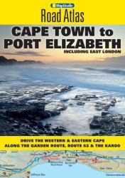
The Cape Town to Port Elizabeth Road Atlas covers the main coastal route of the Western Cape and Garden Route between Cape Town and East London. The atlas provides tourist friendly information, tourism contact details and resources. Included are 1:750 000 scaled maps of the region, a detailed index and street plans of Cape Town, Knysna, Port Elizabeth (including Summerstrand), East London, Mossel ... more details

price history Price history

BP = Best Price   HP = Highest Price

Current Price: R39.00

loading...
Features
Format paperback
ISBN 9781770265301
Publisher map studio
Manufacturer Map Studio
Description
The Cape Town to Port Elizabeth Road Atlas covers the main coastal route of the Western Cape and Garden Route between Cape Town and East London. The atlas provides tourist friendly information, tourism contact details and resources. Included are 1:750 000 scaled maps of the region, a detailed index and street plans of Cape Town, Knysna, Port Elizabeth (including Summerstrand), East London, Mossel Bay, Stellenbosch, Franschhoek, Worcester, Struis Bay, Hermanus, Swellendam, Montagu, Cape Infanta, Hartenbos, Oudtshoorn, George, Wilderness, Sedgefield, St Francis Bay, Jeffrey's Bay, Kenton on Sea, Grahamstown, Port Alfred, Beacon Bay and Kei Mouth.
There are no offers currently available for this product. The last offer was seen on 01/11/2022 from Raru for R39.00
This site is protected by reCAPTCHA and the Google Privacy Policy and Terms of Service apply.