The Living Earth: Pacific Rim View: A Topographical Satellite Mural


The Living Earth: Pacific Rim View: A Topographical Satellite Mural
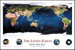
Spaceshots The Living Earth: Pacific Rim View: A Topographical Satellite Mural is a 54" x 36" satellite map made of Landsat, NOAA, and AVHRR data. This is the mural version of Spaceshot's Pacific Rim image of the Living Earth data set. The vast Pacific Ocean is front and center in this smooth combination of satellite data with ocean depth detail. National boundaries are subtly marked... more details

price history Price history

BP = Best Price   HP = Highest Price

Current Price: R1 725.00

loading...
Features
Manufacturer Unbranded
Model Number B001IUT9A8
Description
Spaceshots The Living Earth: Pacific Rim View: A Topographical Satellite Mural is a 54" x 36" satellite map made of Landsat, NOAA, and AVHRR data. This is the mural version of Spaceshot's Pacific Rim image of the Living Earth data set. The vast Pacific Ocean is front and center in this smooth combination of satellite data with ocean depth detail. National boundaries are subtly marked in gold without detracting from the overall picture. The Brilliant Earth is the perfect companion to this image.

One-sided, paper map.
Equatorial Scale: 1:30M
Projection: Mercator
There are no offers currently available for this product. The last offer was seen on 02/08/2023 from WantItAll.co.za for R1 725.00
This site is protected by reCAPTCHA and the Google Privacy Policy and Terms of Service apply.